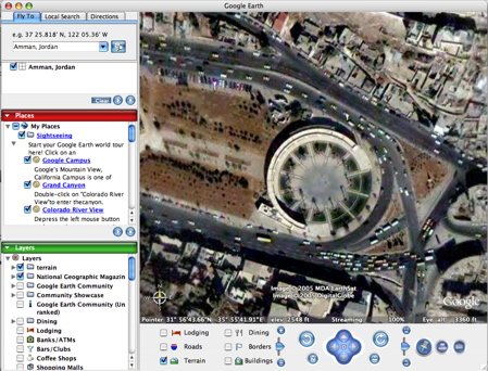
Yipee.. I got my hands on the leaked version of Google Earth for MacOS X. It worked, but also crashed on me once already. I hope the official version will be out soon. Now here’s a quiz for you. What is the landmark showing in the screenshot above.
Yipee.. I got my hands on the leaked version of Google Earth for MacOS X. It worked, but also crashed on me once already. I hope the official version will be out soon. Now here’s a quiz for you. What is the landmark showing in the screenshot above.
by
Tags:
Comments
11 responses to “Google Earth for Mac.. and a little quiz!”
now i haven’t been there since it was built, but isn’t that the theater in ras al ein?
Thanks for the update. It’s downloading as I type.
isnt this down after the amman municipality building downtown?
hey i know.. that’s masra7 il 7ussein.. the library i believe. ras il 3ein.
Hmmm, isnt that beside city hall in nus el balad ?
It’s “sa7et el nawafeer” at the end of the city hall complex in ras el ain :S
Yeah .. that is near the municipality in ras el 3en
it is sahat alnawafeer in ras elein…
shoo ma fi jawa2iz?
Wael’s answere was the most acurate: The circular plaza, “sa7et el nawafeerâ€, at the end of the city hall complex in ras el ain, downtown Amman. Designed by our dear freind (and teacher) Bilal Hammad and his team..
Sorry, no prizes for that one
Hi All Experts,
Does anyone use google earth images as ground image planes for use in aerial scenes. I know how to stitch them together but are there any tools or tricks to make sure that the images are at the same height, angle and such to make sure they stitch well. I know in the pro version you can get bigger images but im not going to pay for the pro version when i could stitch multiple images together…