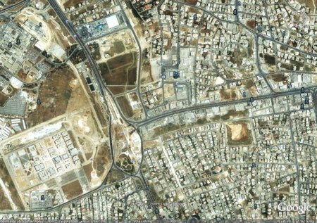
I was alerted (actually by my mother-in-law) that Amman’s Google Earth satellite photography has been updated. I just checked and it’s indeed true. The previous Amman satellite photos where at least 18 months old if not older. The area in the screen shot above is of the Mecca Street/Medical City Road intersection. As you can see, the photo shows that the intersection is still under construction. Based on that and on the fact that some greenery can be seen in the fields, I guess that the images are from last spring. I checked some other construction sites that I know too to confirm that guess.
The question is: is the quality of the photographs lower. Have you noticed less detail? Or more?
Comments
9 responses to “Amman updated on Google Earth, but with less detail?”
The satellite photos were updated about three months ago, I believe the quality of the images are the same quality as before. Not bad for a city in the ME.
i read the title of your post first and the first thought that came to me was “how the heck does he know about these things!” and you answered my instinctive question in the first line, although the answer only begs a second and more obvious question!
as for google…it’s a bit fuzzier but you can still see the red qarmeed and all the swimming pools
As far as I can tell the details are the same but the images are not that recent.
Ya I thought so too, I would say these images are from around 05/08
My two cents are that the images are licensed by satellite imaging companies (believe it or not, there are a number of them), some come free some paid, especially higher resolution ones and the most costly are the aerial photos that requires numerous sweeps by actual airplanes rather than controlling spysat-like satellites to zoom to your desired location.
I once checked with one of them companies and a 1km resolution image for an area of 10km squared awould’ve costed me 4 figures along with being questioned by FBI, NSA, CIA & the local authorities.
i would say its early summer this year.
you can also see the construction going on the buildings of “el ri2aseh”
“el qeyadeh” sorry for the mistake
I’m checking google maps via my iPhone, and yeah there very updated this time.. Coz now I can see the airport road detour, and the “underconstruction” road that links abdoun to marj il hamam, bayader & dair ghbar… And since I moved recently to al marj, my life is gonna get much easier with this new road… I love GPS… And speaking of GPS, what happened to those guys who were working on updating jordan’s map and introducing the GPS device for cars?? Coz it’s sad to see all Amman streets under the name of Amman bas!!
As of today, it looks like Amman has gained roads, many of which have names! Amazing – I can see Maen ben Zaeda, the street I live on, with the name in tiny letters on it. That’s excellent, I was planning on trying to design a .KMZ file which would add street names to my own copy of Google Earth but this is so much better.
Mabrook for us all!
~ زاك